UK Postcodes

The Importance of A Correct Postcode
Postcodes are alphanumeric codes used in postal addresses to facilitate mail sorting and delivery. They help identify specific geographic areas, ranging from individual residences to entire neighbourhoods. In the UK postcodes play a vital role in various aspects of daily life, including mail delivery, emergency services, and navigation. They streamline logistics and ensure timely and accurate deliveries. We have made it easy for you to find the correct UK postcodes to eliminate any confusion or delays on your deliveries. Another helpful information page from SARR Logistics UK to streamline supply chains around the UK, helping companies make the right decisions.
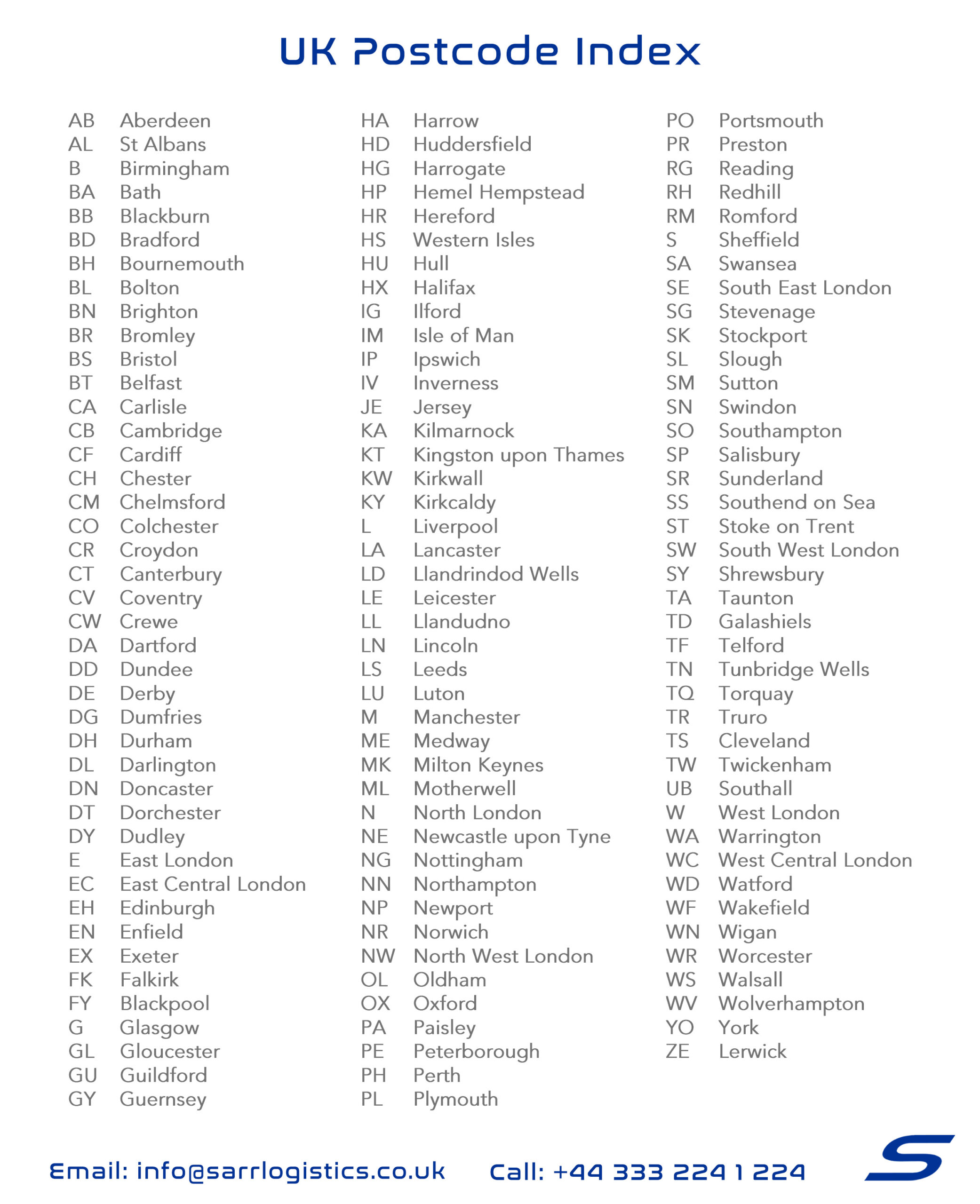
UK Postcodes
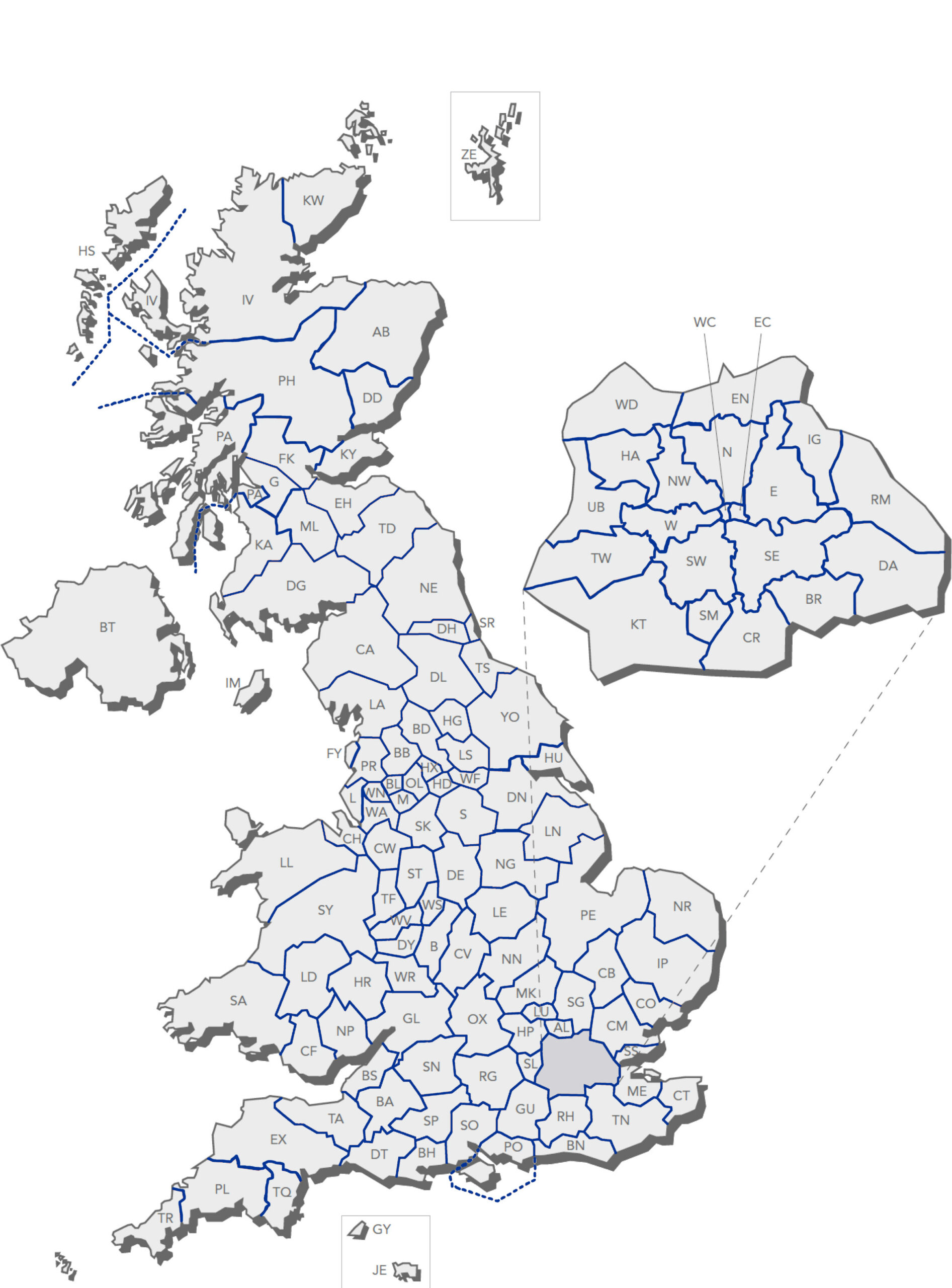
UK Postcodes MAP


SARR Logistics UK
If you are looking for a freight forwarding company, the choice of SARR Logistics UK stands as a testament to reliability, proficiency, and unwavering commitment. With a legacy built on trust, backed by extensive experience, a global network, and a customer-centric approach, SARR Logistics UK emerges as the ultimate partner for all your freight forwarding needs. We constantly try to improve by listening to customers requests and needs. Which is why we have now given our customers this UK postcodes map, we also would like to recommend if you require the number of postcode districts within an area to visit Wikipedia here.
Reach out to us today and experience a seamless, efficient, and dependable shipping solution tailored to elevate your business. For further inquiries and to explore how SARR Logistics UK can revolutionize your shipping experience, contact our team today and embark on a journey of unparalleled logistical efficiency.
Understanding UK Postcodes:
Introduction
Postcodes are more than just a string of letters and numbers tacked onto an address. In the UK, they play a crucial role in everything from directing mail to determining insurance premiums. Understanding the intricacies of the UK postcode system can provide valuable insights into geographic, demographic, and economic trends. This guide will explore the UK postcode system in depth, offering a detailed look at its structure, uses, and significance.
The History of UK Postcodes
The UK’s postcode system has a fascinating history that dates back to the mid-19th century. Initially, postcodes were introduced to simplify the growing demands of mail delivery in urban areas. The first iteration, known as the “London Postal District,” was introduced in 1857, covering the rapidly expanding city of London.
Over time, the system evolved to cover the entire country. The modern alphanumeric postcode system was officially launched in 1959 by the Royal Mail. This innovation allowed for a more efficient sorting and delivery process, reducing the workload on postal workers and increasing the speed of mail distribution across the UK.
The Structure of UK Postcodes
UK postcodes are structured to provide detailed information about specific locations. A typical postcode is composed of two main parts: the outward code and the inward code.
Outward Code: This is the first part of the postcode (e.g., “SW1A”) and typically contains one or two letters followed by one or two digits. It identifies the broader area, such as a town or city.
Inward Code: The second part (e.g., “1AA”) is used to narrow down the location to a more specific address, such as a street or building. It typically consists of a single digit followed by two letters.
For example, in the postcode “SW1A 1AA”:
- “SW” represents the area of South West London.
- “1A” refers to a specific district within that area.
- “1AA” identifies a particular building or group of buildings.
Different Types of Postcodes
UK postcodes come in various forms, depending on the level of detail required:
Full Postcodes: These provide the most precise location information, down to a few addresses or even a single building. Example: “SW1A 1AA” (Buckingham Palace).
Outward Codes: These are less specific and identify larger areas within a city or region. Example: “SW1” covers parts of Westminster in London.
Postcodes are further divided into:
- Postcode Areas: Broad geographic areas, typically covering a town or city (e.g., “SW” for South West London).
- Postcode Districts: Subdivisions within postcode areas (e.g., “SW1”).
- Postcode Sectors: Smaller subdivisions within districts (e.g., “SW1A”).
How Postcodes Are Assigned
The Royal Mail is responsible for assigning postcodes in the UK. This process involves careful consideration of several factors, including geographic boundaries, population density, and the need for efficient mail delivery routes.
Postcodes are designed to make sorting and delivering mail as efficient as possible. The Royal Mail constantly updates and revises postcode areas to accommodate new developments, such as housing estates or business parks. In some cases, postcodes are realigned or modified to reflect changes in the urban landscape.
The Geographic Significance of Postcodes
Postcodes are not just random codes; they are tied closely to geographic areas. Each postcode corresponds to a specific location, which can range from a single address to a larger area with multiple streets.
This geographic significance makes postcodes invaluable for mapping and navigation purposes. Whether you’re using a GPS system or a traditional map, postcodes can help pinpoint exact locations with remarkable accuracy.
The Role of Postcodes in Addressing and Mail Delivery
Postcodes are essential for the efficient sorting and delivery of mail. When you drop a letter into a post-box, the postcode is the key piece of information that helps the Royal Mail direct it to its destination. Sorting offices use the postcode to quickly route the mail to the correct delivery office, where it is then distributed to the appropriate address.
Without accurate postcode information, mail delivery can be delayed or misdirected. This is why it’s crucial to always include the correct postcode when addressing mail.
 Postcodes and Demographics
Postcodes are also a valuable tool for analysing demographic data. Researchers and businesses use postcode information to study population trends, socioeconomic factors, and consumer behaviour.
For example, postcodes can be used to identify areas with high concentrations of certain age groups, income levels, or ethnic communities. This data is invaluable for businesses looking to target specific markets or for local governments planning public services.
Postcodes in Marketing and Business
In the business world, postcodes are a powerful tool for marketing and customer targeting. Companies use postcode data to segment their customer base and tailor their marketing efforts to specific regions or demographics.
For instance, a company selling high-end products might target customers in affluent postcode areas, while a local business may focus its marketing on postcodes within a certain radius of its store.
In e-commerce, postcodes are critical for logistics and delivery planning. Accurate postcode data ensures that orders are delivered promptly and efficiently, reducing the likelihood of errors and improving customer satisfaction.
Postcodes and Property Prices
The value of a property in the UK can be closely tied to its postcode. In general, certain postcode areas are associated with higher property prices due to factors such as proximity to city centres, good schools, and desirable amenities.
For example, properties in the “W1” postcode area of central London are among the most expensive in the country, reflecting the area’s prestige and prime location. Conversely, postcodes in less desirable areas may be associated with lower property values.
Postcodes and Public Services
Postcodes play a crucial role in determining access to public services such as healthcare, education, and emergency response. For example, hospital catchment areas are often defined by postcode boundaries, which can affect where patients are eligible for treatment.
Similarly, school admissions are often influenced by postcode, with families in certain areas having priority access to nearby schools. This can lead to fierce competition for homes in sought-after postcode areas with good schools.
In emergency services, postcodes are used to quickly locate addresses and direct first responders to the scene. Accurate postcode information can be a matter of life and death in critical situations.
Challenges and Issues with UK Postcodes
Despite their many benefits, the UK postcode system is not without its challenges. One common issue is the frequent changes and updates to postcode areas, which can create confusion for residents and businesses.
In some cases, postcode changes can have significant implications, such as altering insurance premiums or affecting school catchment areas. Additionally, there are instances where a single postcode covers a large, diverse area, leading to discrepancies in services or property values.
Technology and Postcodes
Technology has played a significant role in the evolution of the postcode system. Modern tools like geocoding, which converts addresses into geographic coordinates, have enhanced the precision and usefulness of postcodes. These advancements have opened up new possibilities in areas such as logistics, urban planning, and even disaster management.
For example, geocoding allows businesses to map out customer locations more accurately, optimizing delivery routes and reducing transportation costs. Urban planners can use postcode data to better understand the spatial distribution of populations, helping to design more efficient public transport systems and infrastructure projects.
Additionally, technology has enabled the development of postcode-based applications and services. For instance, apps that provide local information, such as nearby restaurants or healthcare services, often rely on postcode data to deliver relevant content to users. Similarly, emergency services can use real-time postcode data to deploy resources more effectively during a crisis.
 The Future of UK Postcodes
As technology continues to advance, the UK postcode system is likely to undergo further changes and improvements. One potential development is the integration of more precise location data, such as GPS coordinates, into the postcode system. This could enhance the accuracy of location-based services and improve the efficiency of mail delivery and logistics.
Another possibility is the adoption of dynamic postcodes that can change in real-time based on factors like population density or traffic conditions. This would allow for more flexible and responsive postcode allocation, helping to address some of the challenges currently faced by the system.
Moreover, with the rise of smart cities and the Internet of Things (IoT), postcodes could become even more integrated into everyday life. Smart devices and sensors could use postcode data to provide personalized services and improve urban management, such as optimizing energy usage or monitoring air quality.
However, any changes to the postcode system will need to be carefully managed to avoid disruption to residents and businesses. The Royal Mail and other stakeholders will need to work together to ensure that any new developments are implemented smoothly and that the benefits are widely shared.
Conclusion
UK postcodes are more than just a means of directing mail; they are a vital part of the country’s infrastructure. From facilitating efficient mail delivery to providing valuable insights into demographics and property values, postcodes play a crucial role in many aspects of everyday life.
As we’ve seen, the UK postcode system has a rich history and a complex structure that reflects the diversity and complexity of the country itself. Whether you’re a business owner looking to target customers more effectively, a homebuyer seeking the perfect location, or simply someone who wants to understand more about their community, postcodes can offer a wealth of information.
Looking ahead, the future of UK postcodes is likely to be shaped by ongoing technological advancements. As the system evolves, it will continue to play a central role in everything from urban planning to e-commerce, ensuring that the UK remains connected and efficient in an increasingly digital world.
FAQ
1. What is the significance of the first two letters in a UK postcode?
The first two letters of a UK postcode, known as the outward code, indicate the broad geographical area, such as a city or region. For example, “SW” stands for South West London, while “B” represents Birmingham. This part of the postcode helps to direct mail to the correct regional sorting office.
2. How often do postcodes change in the UK?
Postcodes in the UK can change due to various factors, such as new housing developments, changes in local infrastructure, or adjustments to improve mail delivery efficiency. While changes are not frequent, they do occur, and the Royal Mail regularly updates postcode information to reflect these changes.
3. Can two different locations share the same postcode?
Yes, it is possible for multiple addresses or even streets to share the same postcode, especially in rural areas or smaller towns. However, within cities, postcodes are generally more specific, with each one typically covering only a few addresses or a single building.
4. How are postcodes used in online shopping?
In online shopping, postcodes are crucial for determining delivery options and costs. Retailers use postcode data to calculate shipping fees, estimate delivery times, and ensure that products are sent to the correct address. Accurate postcode information helps prevent delays and errors in the delivery process.
5. What should I do if my postcode is not recognized?
If your postcode is not recognized by a system, it could be due to a recent change or an error in the database. You can contact the Royal Mail to confirm your postcode and report the issue. Many online platforms also allow users to manually enter or correct their address details if the postcode is not found.


 Postcodes and Demographics
 The Future of UK Postcodes